
")
 in opposite directions.)
Simon Scarr, Vijdan Mohammad Kawoosa and Jitesh Chowdhury reports about the day the Earth moved in Reuters on February 17, 2023.
The ground in Turkey and northern Syria was torn, cracked open, and dragged in different directions after the massive 7.8 magnitude quake and its aftershocks on Feb. 6.
The map below illustrates how far the surface moved during the quake. Two clear ruptures now stretch for hundreds of kilometres where the land moved up to 7 metres (23 feet) in opposite directions.
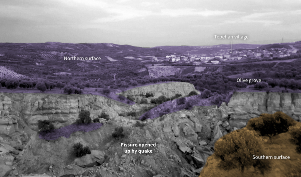
Even at the southern tip of the larger rupture, about 150 km from the epicentre of the initial 7.8 magnitude quake, the village of Tepehan, in Hatay province, witnessed extraordinary cracks tearing through the surface.
Drone footage filmed on Feb. 10 showed fissures slicing across an olive grove in the village.
« At around 4:20 a.m. (0120GMT) at night, we woke up to a noise. With the initial panic, nobody knew whether we could leave home or whether we could survive. We lost hope, » said local resident Mehmet Temizkan.
“These were very large and powerful earthquakes that ruptured all the way up to the surface over a long series of fault segments,” Eric Fielding, a geophysicist at NASA’s Jet Propulsion Laboratory, said in a statement on the agency’s Earth Observatory website.
“This generated extremely strong shaking over a very large area that hit many cities and towns full of people,” he said. “The rupture length and magnitude of the magnitude 7.8 earthquake was similar to the 1906 earthquake that destroyed San Francisco.”
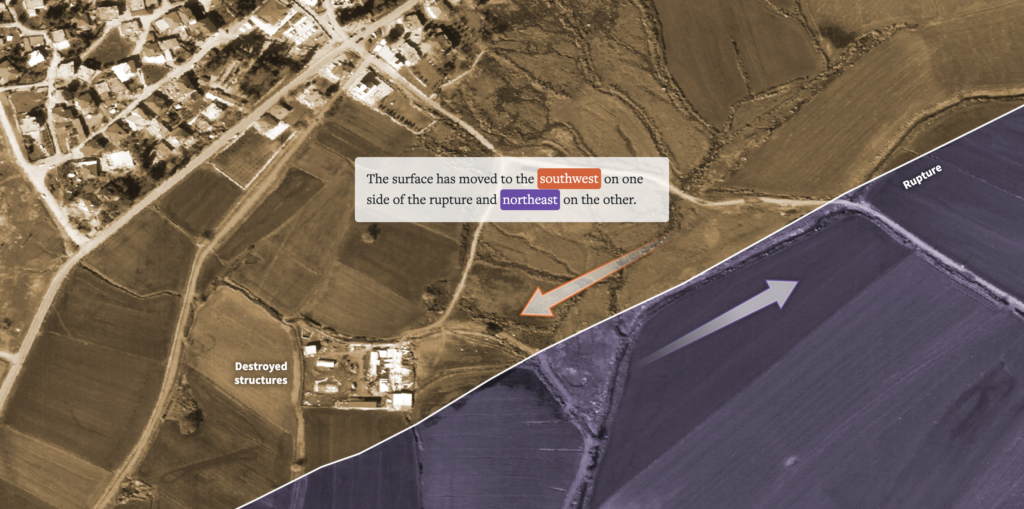
Land on either side of the ruptures moved in opposite directions, settling up to 7 metres from its starting point in some locations, according to data provided by Chris Milliner of the California Institute of Technology.
Ruptures from the two quakes
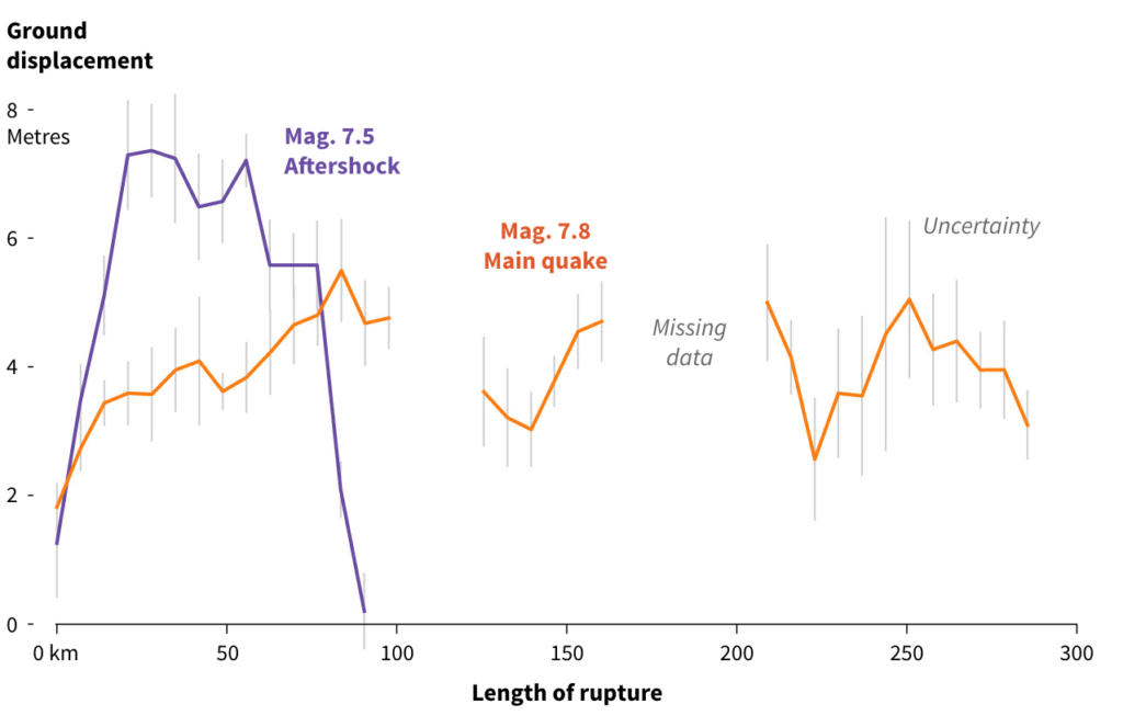
The main quake had a long rupture with displacements of up to 5m. The shorter rupture from the 7.5 aftershock saw larger land displacements of up to 7m in places.
Joining the dots
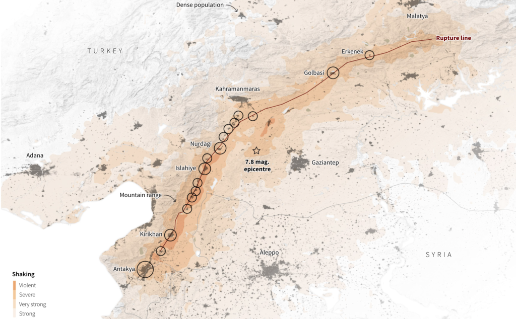
The smaller towns directly above the fault line suffered some of the most severe shaking. The main rupture tore straight through many of these settlements as if it were joining the dots on a map.
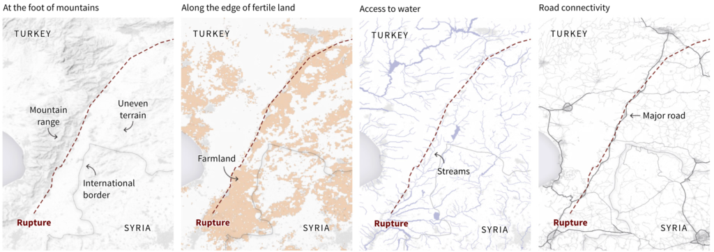
Susan Hough, a seismologist at the United States Geological Survey, said that in many cases, people end up living next to fault zones for resource reasons.
“If you are living along the base of the mountains, there may be more water there,” Hough said.
Many of the towns lie at the foot of a mountain range to the East.
Possible reasons for human settlement along the fault
A Reuters analysis of population estimates shows that the settlements built near the fault zone tended to have higher populations the closer they were to the rupture. Many of the fatalities and building collapses happened in larger cities distant from the fault zone, however, which experts said related to the underlying geography.
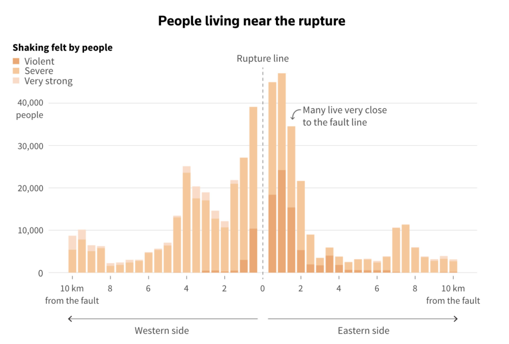
Margarita Segou, a seismologist with the British Geological Survey, said it is safer to build on mountainous rock than the soft soil of the plains, which tends to amplify ground motion.
Towns torn apart
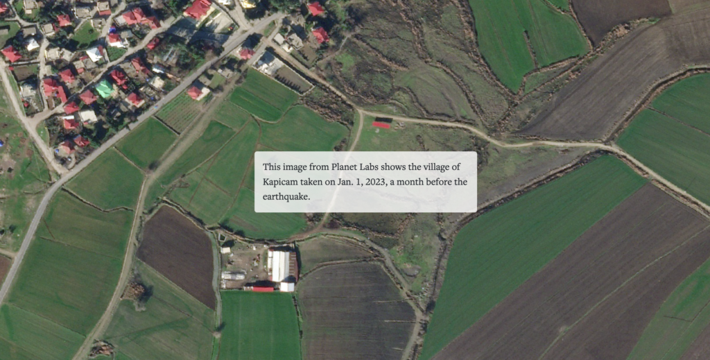
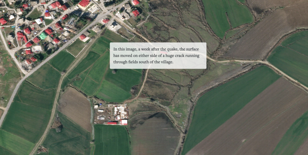
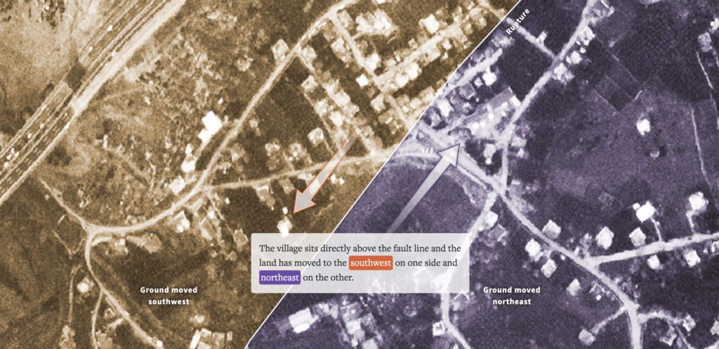
Satellite images clearly showed the surface displacement. The pinpoint accuracy of the images allows the movement of land to be traced.
Images from Planet Labs show a surface rupture running straight through the middle of a village near Nurdagi, Turkey, with the ground clearly moving a few metres on either side.
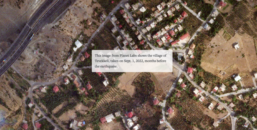
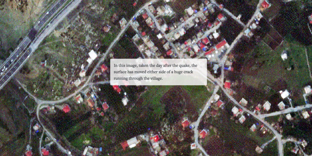
Another image shows a long crack and surface movement near the neighbouring village of Tevekkeli, which sits on the fault line south of Kahramanmaras. The entire village appears to have moved a few metres and cracks slice through fields and tracks.
The scale of the event
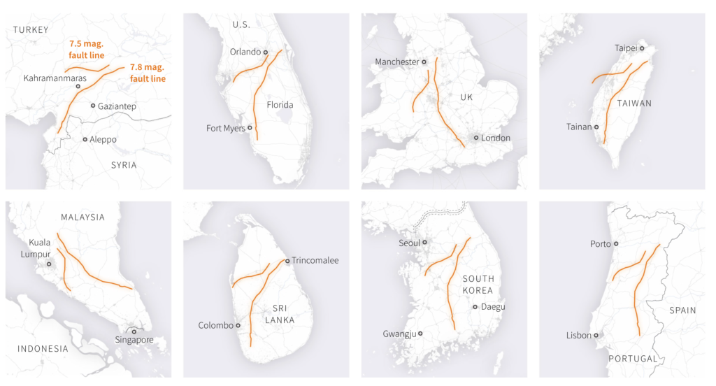
The earthquakes opened two enormous cracks in Earth’s surface, the longer of which stretches about 300km across southern Turkey.
“An earthquake of this size causes the fault to break along quite a long extent,” said Roger Musson, an honorary research associate at the British Geological Survey. The maps below show the size of the ruptures relative to other well-known land masses. The crack is comparable to the length of Taiwan, South Korea, or Portugal.
“To have a fault this long fail in a populated area is horrific,” said Professor Tim Wright, head of the U.K. Centre for the Observation & Modelling of Earthquakes, Volcanoes & Tectonics (COMET).
Experts say the surface ruptures offer a valuable source of data that will help them understand the processes that caused such a devastating event – and ultimately save lives.
“Scientists around the world are using these kinds of data to build ‘source models’ of the event,” Wright said, adding that such models could predict how structures behave during earthquakes and how they might affect key infrastructure such as bridges and roads. “In the longer-term, forensically understanding every earthquake helps us prepare for future events in different regions.”
Correction
This story previously mentioned interchanged displacement measurements for the two ruptures. This has now been corrected to 5m for the longer rupture and 7m for the shorter rupture from the aftershock.
Note
Surface displacement data shows pixel offset tracking in “line-of-sight” from Sentinel-1 satellite on Jan. 29 and Feb. 10.
Satellite images
Planet Labs PBC
Sources
Surface displacement data: U.K. Centre for the Observation & Modelling of Earthquakes, Volcanoes & Tectonics (COMET); Surface rupture traces and shake intensity map: United States Geological Survey; Copernicus Sentinel-1 data 2023, Retrieved from Copernicus SciHub and ASF DAAC February 2023, processed by ESA; Reitman, Nadine G, Richard W. Briggs, William D. Barnhart, Jessica A. Thompson Jobe, Christopher B. DuRoss, Alexandra E. Hatem, Ryan D. Gold, and John D. Mejstrik (2023); Surface rupture chart: Dr. Chris Milliner, California Institute of Technology; Population data: WorldPop project, University of Southampton, and LandScan program, Oak Ridge National Laboratory; Terrain: Shuttle Radar Topography Mission; Borders: Natural Earth; Physical features: OpenStreetMap; Land use data: Esri, Impact Observatory, and Microsoft
Additional work by
Adolfo Arranz
Edited by
Gerry Doyle
Simon Scarr, Vijdan Mohammad Kawoosa and Jitesh Chowdhury reports about the day the Earth moved in Reuters on February 17, 2023.